Underwater Video Surveys
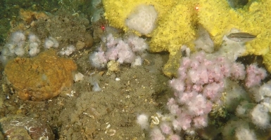
For over 20 years, CR has used underwater surveys to support monitoring programs; eelgrass, epifauna, habitat and substrate mapping; sand resource studies for beach nourishment; and marine engineering projects at wind turbine landing sites, outfalls, pipelines, cable routes, and dredged material disposal sites surveys.
CR personnel are experienced in marine macrofauna identifications and underwater video substrate and biotic classification using the Coastal and Marine Ecological Classification System (CMECS).
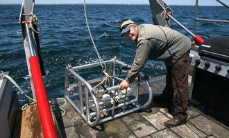
Recent underwater video projects using our custom designed video sled and video grab samplers:
Dredged Material Disposal Site Underwater Video & Sediment Grabs (2022)
- Dredged Material Disposal Site Underwater Video & Sediment Grabs (2022) Maine and the Mass Bay Disposal Sites Kennebunkport and Stonington - ME, and Boston - MA AECOM / US Army Corps of Engineers New England Division
Vineyard Sound 5th and 91B Cable Route Geophysical & Underwater Video Surveys (2021-2022)
- Vineyard Sound 5th and 91B Cable Route Geophysical & Underwater Video Surveys (2021-2022) Martha’s Vineyard to Falmouth, MA Epsilon Associates / Eversource
Wind Turbine Landing Site Eelgrass Video Sled & Single Beam Surveys (2020)
- Vineyard Sound, Falmouth, MA. AECOM / Mayflower Wind
Barnstable Landing Site Underwater Video Sled & Sediment Grab Surveys (2019)
- Centerville Harbor / Nantucket Sound, MA. Seaforth Geosurveys / Vineyard Wind
Video Survey of Sand Resources at Five Massachusetts Study Sites (2018)
- Merrimack River to Buzzards Bay, MA APTIM / MACZM
The video sleds and sediment grab samplers are equipped with Outland Technology and GOPRO HD video cameras, LED video lights, scaling lasers, and LinkQuest USBL tracking systems. Video data is cabled to the surface to consoles with variable output light controls, DVR recorders, and day light viewable monitors with GPS coordinate overlays that allow the scientific crew to record observations in real time.


